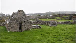
A-B. Leaving the trailhead at the pier, turn left and follow the purple (and green) arrows along the surfaced road. The green arrows are for a shorter loop. After 100m pass a slip on your left and then veer left at a Y-junction - the road to the right takes you to a shop. After 100m you reach Cnoc Raithní and turn left. Follow the road past the GAA pitch and playground and onward past Teampaill Chaomhain (all on your right). Continue to follow the purple and green arrows along the road for almost 2km to reach a the coastline from where you can visit the wreck of the Plassy.
B-C. Follow the coastline for 250m before the road sweeps right and takes you uphill toward the old village of An Formna with good views of An Loch Mór on your right. The loop swings sharp left, exits the village and after 200m turns right onto a sandy track. Follow the track to reach a surfaced road from where O Brien’s Castle is a short detour to your right. The official loop turns left, however, and after 100m passes the ruins of a Signal Tower and schoolhouse before turning right again onto a sandy track.
C-D. Continue to follow the track for 200m to reach a surfaced road and turn right. Shortly afterwards, pass the church ( on your left) and 500m later reach a junction where the green loop turns right but you turn left.
D-E. Follow the purple arrows along the road for almost 2km before turning right onto a ‘green’ roadway. 200m later you reach the coastline and turn right. After 500m watch for a green roadway on your right from where you can make a short detour to Tobar Eanna. The loop, however, continues along the coastline for another 1km before reaching a Y-junction. Take the right fork here and ascend briefly before reaching a T-junction where you rejoin the green loop. A short detour of 30m to your right takes you to Cill Ghobnait - but the loop turns left.
E-A. The loop now starts the descent toward the trailhead - but watch for a right turn which takes you uphill one last time to pass the old Coastguard Station and shortly afterwards reach the ‘centre’ of the village where you can enjoy a cuppa or pint before ambling the last 300m back to the trailhead at the pier.
Trail details
- Type:
- Walking Trail
- Location:
- Inis Oirr Loops
- Grade:
- Moderate
- Format:
- Loop
- Length:
- 11.20km
- Ascent:
- 120m
- Dogs allowed:
- Yes
