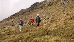
Starting from the car park at the Watering Place follow the tarred road for 400m, past a road on your right, to a laneway on your left. Turn left here.
B-C Following the laneway (which gives way to a sandy lane) you ascend gently for almost 2km to reach a metal gate entrance to an old homestead at Bregaun. Fine views of the Kilkenny countryside begin to open up on your left – and on your right the outline of the trig pillar atop Kilmacoliver Hill becomes visible. Enter the old farm via the metal stile.
C-D Follow the laneway past the old house and farmyard (please do not enter), and shortly afterwards be alert as the loop leaves the laneway to your right and follows a dry ditch on the ascent to the summit of Kilmacoliver Hill.
D-E Take time on the summit to enjoy the views over counties Kilkenny, Tipperary, Waterford, Carlow and Wexford. The substantial hill in front of you is Carrigadoon Hill. Descend downhill following the fence on the boarder of the field and enter privately developed woodland of broadleaf trees including oak, beech, birch, larch, ash and cherry. The trip through the young woodlands is a pleasant one which ends at a metal gate as you re-join the laneway which you travelled outward.
E-A Turning left, you reach a T-junction where you take a right for the final 400m to the trailhead.
Tullahought parish:
The rural parish of Tullahought is situated on the small river Lingam which separates the counties of Kilkenny and Tipperary, and the provinces of Leinster and Munster. The village shows clear signs of rural depopulation being experienced in modern-day Ireland with closed shops and Post Office – but the natives retain a traditional friendly and welcoming nature! Nearby Kilmacoliver Hill (261m) dominates the landscape and the summit of which is adorned by a circular enclosure of standing stones. It is a curious burial ground - whether pagan or Christian is not known. There is also a trig pillar (triangulation pillars used by the Ordnance Survey). On the same hill some curious figures are cut into a large granite rock and nearby, a holy well and three superb old Irish crosses. The area is well known for high quality quarried slate which is similar to Welsh slate in colour and lightness.
Trail details
- Type:
- Walking Trail
- Location:
- Tullahought
- Grade:
- Moderate
- Format:
- Loop
- Length:
- 3.80km
- Ascent:
- 115m
- Dogs allowed:
- No
Kilmaganny: Shop
