A – B. Walk west from the trailhead through the village of Broadford following the yellow arrows. Take the first turn to the left. Walk past the forge and take the next turn right at the road junction. After 500m rejoin the main road turning left. At the next junction walk right and after 100m enter the laneway on the left. Continue along the laneway you come to a Y junction. Veer right.
B – C.
Follow the yellow arrows walk along the laneway. Having passed the ruins of Curramore House on the left go right and continue on until you reach a stile on the left leading you into fields of green pasture. Remaining inside the fence walk through the fields. Soon you will be overlooking the trees of An Gleann Beag. Continue on through the fields and between the ferns. Take a rest on the seat overlooking the picturesque views of West Limerick. Follow the trail until you cross the stile leading you onto a roadway.
C – D.
Walk to the right, following the yellow arrows for 350m until you come to a T junction. Turn right and follow the trail for 2km until you reach another T junction. Walk uphill to the left with beautiful views of the surrounding countryside visible on your right. Go left at the next junction. Following the yellow arrows walk along the quiet roadway until you come to the junction to the right after 1.3km.
D – E.
Continue along through this quiet country lane crossing the bridge over the Glashawee river and entering the Coillte forestry. After 2 km at a junction you notice mapboards for another trail on your left but continue for 100m until you reach the next junction and turn to the right. Continuing to follow the yellow arrows walk along for 100m and then take the forestry road to the right. Continue to the next T junction. Go right and walk the short distance to the main road.
E – F.
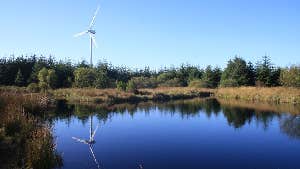
On reaching the main road turn left and continue for 1km until you reach the entrance to Lough Ghé on your right (a wildfowl sanctuary within a National Heritage Area of blanket bog). Having visited Lough Ghé return to the road, turning right and following the yellow arrows, after 300m you meet a junction but keep right and follow the yellow arrows for another 350m and at the second forestry junction go right which will take you between rows of sitka spruce for 2km. Follow the route to the left along the forest path which in springtime is alive with tadpole spawn. The route leads you over 2 stiles and past old farm buildings before reaching a roadway. Turn right and walk for 180m before entering the downhill trail known as The Cobs Road. At the bottom of this hill turn left which will lead you to the trailhead in Ashford.
Trail details
- Type:
- Walking Trail
- Location:
- Broadford Ashford Walking Trails
- Grade:
- Strenuous
- Format:
- Linear
- Length:
- 19.00km
- Ascent:
- 287m
- Dogs allowed:
- No
In Ashford: Car parking, pub
